
Protecting biodiversity along the Swedish seabed
Using satellite imagery with AI, the County Administrative Board of Västerbotten can now continuously analyze the coastal seabed with an effective and scalable solution.
Client: County Administrative Board (Länsstyrelsen) of Västerbotten, financed by the Swedish Agency for Marine and Water Management
Region: Sweden
Industry: Public Sector
Offer: Data & AI
About the County Administrative Board and their goals
The County Administrative Board (Länsstyrelsen in Swedish) is the state authority responsible for sustainable development. It balances the environment, economic growth, and a stable job market thus leading to the well-being of residents.
The County Administrative Board is helping the Swedish Agency for Marine and Water Management to map Sweden's coastal seabed. The goal is to monitor changes in the environment caused by factors like climate, emissions, and human impact.
Challenges in coastal seabed monitoring
Effective management of coastal resources requires a comprehensive understanding of the seabed and its ecosystems. In particular, it needs data enabling the monitoring of changes linked to human activities and climate change.
This data is crucial for the early detection of potential issues while taking proactive measures to address challenges. Also, it is needed for planning and implementing policies and initiatives for coastal development and environmental conservation.
Traditional data collection methods, such as using boats, diving, and drones, are expensive and limited in their scope and frequency. For example, the County Administrative Board had to laboriously label Submerged Aquatic Vegetation (SAV), sand, and rocks in numerous satellite images each year. This approach was time-consuming as they had to repetitively label regions on each image. Even if an Artificial Intelligence (AI) model could be trained, new training data was needed annually, driving costs and reducing the flexibility of the approach.
The County Administrative Board wanted to overcome these limitations by using satellite imagery and AI, specifically Geo Satellite Intelligence (GSI), to map the seabed. This allowed for the continuous analysis of Sweden’s coasts more effectively and with a scalable approach.
Leveraging expertise and specialized tools to efficiently map the seabed
The County Administrative Board needed a partner with expertise in AI and geospatial technology. They identified Sogeti who has a track record of successfully completing similar projects combining AI, geospatial analysis, and remote sensing.
Sogeti presented a solution which would improve data quality and increase monitoring frequency leading to data-driven decision-making. In collaboration with Sogeti, they developed an AI model and utilized efficiency-boosting tools within the GSI framework for remote analysis. This allowed for the processing of large volumes of data, enabling more comprehensive and accurate seabed mapping.
Using the satellite images previously used, Sogeti leveraged their proven expertise and specialized tools to efficiently map them. They employed a framework tailored for training image-based models, enabling rapid experimentation with various models and data utilization methods. This approach facilitated seamless comparison of results, allowing for a comprehensive assessment of the images.
Sogeti used several essential tools for this project starting with the ‘LocalAnalysisTool’. This simplifies downloading and data processing from satellites like the Sentinel-2 which takes detailed pictures of the Earth’s surface. The tool made it easy to select, format, and analyze these satellite images.
Second, Sogeti utilized their own code for working with Geographical Information System (GIS) data. This made it simpler to handle geo-located images and geographic shapes, such as polygons representing vegetation, sand, and stones. This ensured well-organized data.
Lastly, Sogeti had a flexible framework for training deep-learning models for images. This allowed Sogeti to experiment and fine-tune the model easily, even when dealing with incomplete SAV information within images.
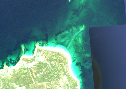
RGB view of a Sentinel-2 image (10m resolution) saturated to better see SAV.
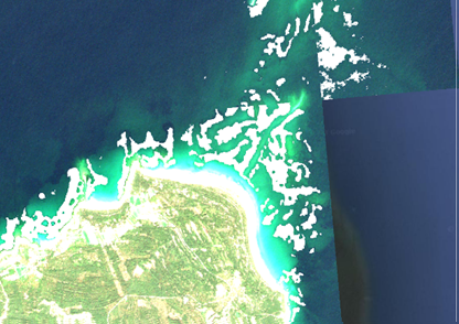
Same image but overlapped with the predictions from the deep learning model in white labels.
Benefits of the new solution
Accuracy: The model's accuracy was very promising on training and validation data, with an Intersection over Union (IoU) metric score of greater than 0.98, with 1 indicating a perfect overlap between the predicted and ground truth regions in an image.
Data-Driven Decision-Making: By utilizing satellite-based data and AI models, it’s evident that this method is more accurate for frequent seabed mapping, enabling continuous monitoring and evidence-based decision-making.
Increased Mapping Frequency: By utilizing satellite data, it is possible to map Sweden's coasts more frequently, even monthly, instead of annually or less often. This increased frequency provides more up-to-date and accurate data.
Cost Reduction: Utilizing this method, the County Administrative Board has the potential to reduce the costs associated with traditional monitoring methods, such as drones, boats, and divers.
Identify Damages and Changes: By using methods based on satellite monitoring, damages and changes to the coastal environment can be quickly identified, especially in crucial ecosystems such as eelgrass. This information helps to take timely and effective measures to address changes.
While this project has provided valuable short-term insights, it has the potential of a long-term impact of establishing a sustainable and practical solution for continuous coastal seabed monitoring. This will ensure the well-being of the environment and the people living in coastal regions.

Geo-satellite Intelligence
Curious about the transformative power on what AI can do with data for your business?
Geo-satellite Intelligence
Curious about the transformative power on what AI can do with data for your business?